Anchorage Maps and Orientation
(Anchorage, Alaska - AK, USA)
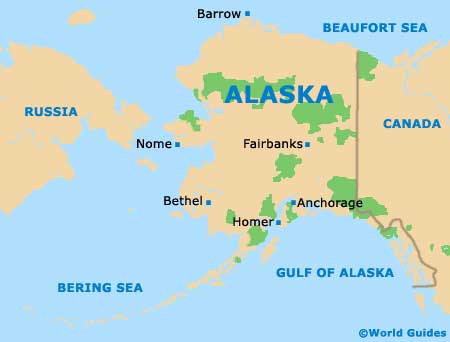
Located on the far southern side of Alaska and next to the coastline, the city of Anchorage is the state's biggest city, although it is the much smaller city of
Juneau that actually serves as the state capital. Anchorage resides within the Alaskan borough of the same name, where it lies at the foot of the Chugach Mountains and its state park.
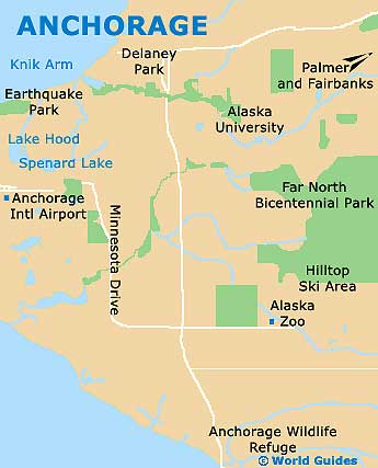
Point Campbell forms the most westerly part of mainland Anchorage and enjoys a scenic setting next to the Cook Inlet. While the coastline may look inviting, visitors are advised to be especially wary of the mud-flats and the rapid tidal changes.
If you are planning to drive to Anchorage, complete with map or sat-nav, then you will most likely arrive either from the Glenn Highway (north) or the Seward Highway (south). Delaney Park forms a sizeable piece of green in downtown Anchorage itself, being found in between West 9th Avenue and West 10th Avenue.
Maps and Orientation of the City
Downtown Anchorage is perfect for those who like to get around on foot, with its pedestrian-friendly streets being structured in a regular gridwork formation.
When following maps, look out for prominent reference points, such as the Alaska Court System on West 3rd Avenue, the Holy Family Cathedral and the William A. Egan Civic and Convention Center on West 5th Avenue, and the Alaska Center for the Performing Arts on West 6th Avenue. On the western side of downtown Anchorage you will find Elderberry Park and the Oscar Anderson House Museum.
Finding your way around the city is made all the easier once you realize that, in general, avenues heading in an east to west direction are numbered, while those heading north to south are named after letters, in an alphabetical fashion.
- Butte - 42 miles / 68 km (one hour and ten minutes, northeast)
- Chugach State Park - 35 miles / 56 km (50 minutes, east)
- Eagle Bay - 22 miles / 35 km (30 minutes, northeast)
- Fairbanks - 360 miles / 579 km (nine hours, north)
- Far North Bicentennial Park - 9 miles / 14 km (15 minutes, southeast)
- Fishhook - 53 miles / 85 km (one hour and 15 minutes, northeast)
- Gateway - 39 miles / 63 km (one hour, northeast)
- Homer - 223 miles / 359 km (five hours, southwest)
- Knik-Fairview - 50 miles / 80 km (one hour and 15 minutes, northeast)
- Lazy Mountain - 52 miles / 84 km (one hour and 15 minutes, northeast)
- Palmer - 43 miles / 69 km (one hour and ten minutes, northeast)
- Sutton-Alpine - 57 miles / 92 km (one hour and 25 minutes, northeast)
- Wasilla - 43 miles / 69 km (one hour and ten minutes, northeast)
Map of the United States

Map of Alaska
Map of Anchorage